
CzechAID Project
Project: Strengthening the forest monitoring capacity of Ukraine for EU Compliance
This project is carried out with the financial support of the Czech Development Agency, under the Memorandum of Understanding (UHUL/1045/2024/FM) between the following partners:
· Forest Management Institute (Czech Republic)
· State Forest Resource Agency of Ukraine
· Production Association “Ukrderzhlisproject”
· Ukrainian Research Institute of Forestry and Forest Melioration named after G.M. Vysotsky
· National University of Life and Environmental Sciences of Ukraine.
Project Goals
The project aims at strengthening the capacity of Ukraine to monitoring forests using remote sensing (RS) technologies. By linking research, education, and practical applications, the project focused on:
· Establishing a modern classroom for RS and GIS data processing
· Knowledge exchange between experts from Czech Republic and Ukraine
· Improving methodologies for producing forest maps from satellite data
· Updating university courses in line with project outcomes
· Building long-term expertise in forest monitoring to support Ukraine’s compliance with EU standards.
Implementation of the Project
Establishing the Remote Sensing laboratory
A major achievement of the project is the creation of a specialized classroom for RS and GIS data processing dedicated to forestry students. With the financial and technical support from the project, the Laboratory for Remote Sensing Forest Monitoring was established at the Department of Forest Mensuration and Forest Management (university Order No 359, April 2, 2025). The laboratory was inaugurated on July 22, 2025 during the International Workshop on the Implementation of the Best Practices on Forest Monitoring in Ukraine using Remote Sensing Technologies.
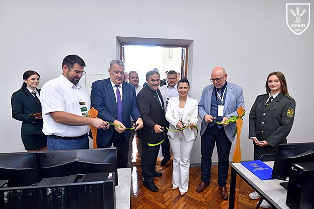
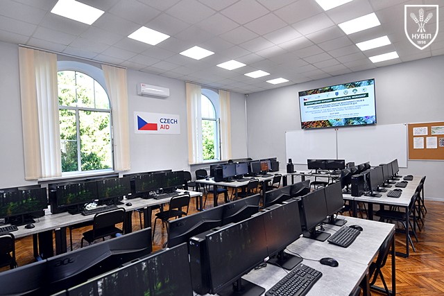
Left photo: Opening ceremony of the newly established classroom on July 22, 2025. Romand Vasylyshyn (Director of the Institute of Forestry and Landscape Gardening), Vadym Tkachuk (Rector of NUBiP of Ukraine), Marek Mlčoušek (Branch Director of the Forest Management Institute, Project Manager), Mariana Ostrovska (Head of the Sector of International Relations, Science, and Public Relations of the State Forest Resource Agency of Ukraine), and Radek Pech (Ambassador of the Czech Republic to Ukraine) are cutting ribbon. Right photo: Newly equipped computer laboratory supported by the project.
International Workshop on Remote Sensing in Forest Monitoring
The International Workshop on the Implementation of the Best Practices on Forest Monitoring in Ukraine using Remote Sensing Technologies was held at NUBiP of Ukraine on July 22, 2025.
The workshop served as a platform for sharing knowledge and experience among researchers, students, practitioners, and policy-makers on the application of remote sensing tools in forest monitoring. It brought together about 60 participants from Ukraine.
A practical training session was conducted in the newly established laboratory under mentorship of Dr. Peter Lukes and Dr. Filip Hajek, offering hands-on experience with advanced RS technologies.
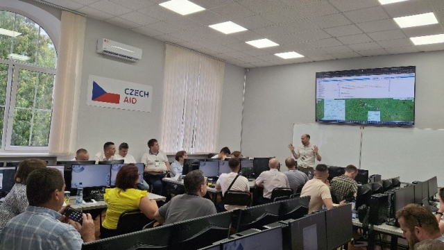
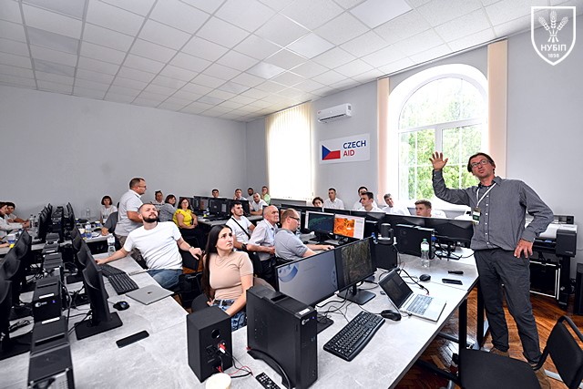
Left photo: Dr. Petr Lukes presenting practical applications of web-based tools for forest monitoring. Right photo: Dr. Filip Hajec explaining the process of visual interpretation of satellite images using Collect Earth software.
More details about the workshop are available at: https://nubip.edu.ua/news/ukrayina-chekhiya-doslidzhuvaty-zberihaty-prozoro-oblikovuvaty-ukrayinski-lisy-z-kosmosu
Training Courses
The project has also contributed to the modernization of forestry education at the university:
· In cooperation with Czech partners, a new Bachelor-level course titled Remote Sensing Forest Monitoring was developed. During the first year of implementation year, it engaged 70 full-time students, while more than 50 part-time students completed selected practical assignments. An online version of the course is available on the NUBiP E-learning Portal (https://elearn.nubip.edu.ua/enrol/index.php?id=4103).

· At the Master level, two elective courses have been improved:
o Forest Inventory and Monitoring now integrates the methodology of visual interpretation of satellite images using Collect Earth
o Forest Inventory and Mapping incorporates web-based solutions for forest mapping proposed in the project.
Improving Forest Resource Mapping using Canopy Height Models (Ongoing)
This activity builds on the existing nationwide framework for forest resource mapping in Ukraine (Myroniuk et al., 2024; https://doi.org/10.1016/j.foreco.2024.122156) and seeks to enhance accuracy by integrating global canopy height models.
Preliminary results indicate that including the most recent canopy model by Pauls et al. (2025; https://doi.org/10.48550/arXiv.2501.19328) into a workflow based on forest inventory data and Sentinel 2 images can improve the prediction of forest attributes, increasing R-squared values from 0.2–0.4 (optical data only) to 0.4–0.6 (optical + canopy height data).
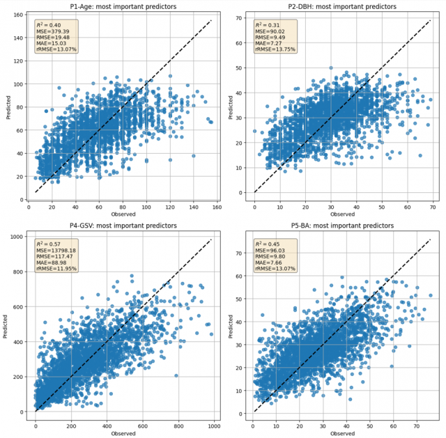
Scatterplots showing the relationship between field-observed forest attributes and their satellite-based prediction.
Mapping Dominant Species using PlanetScope imagery (Ongoing)
Another research direction demonstrates the potential of multi-date PlanetScope imagery for tree species classification. The study area is the Kalush district of the Ivano-Frankivsk oblast, covering approximately 300,000 km2.
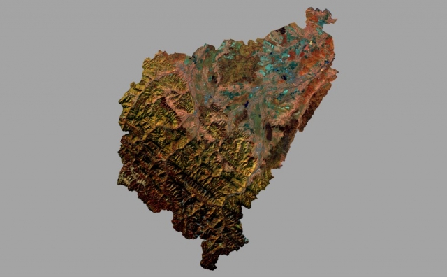
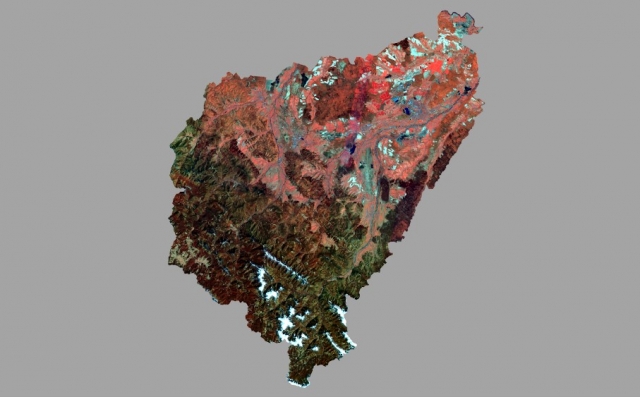
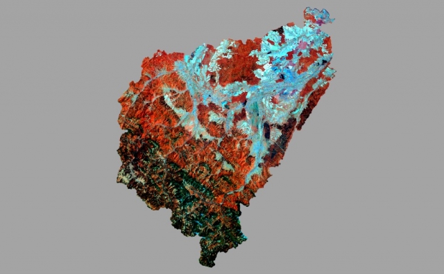
Cloudless mosaics of PlanetScope images: left – May, 2021-2023, center – June 2022, right – October 2022.
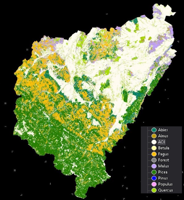
Prototype of tree species map derived from PlanetScope imagery
The final map will be available on this site upon completion of the project.
Explore Project Outputs
Forest Health Trends in Ukraine (2019-2025)
The forest health trends of Ukraine are visualized through a dynamic Google Earth Engine (GEE) web map, which displays both short-term (2022-2025) and medium-term (2019-2025) forest health trends. The maps show the slope of the regression line for the Wetness component of the Tasselled Cap transformation, derived from yearly cloud-free mosaics.
To create these maps, the first step was to calculate the median reflectance for cloud-masked pixels between June 1st and August 31st, using the Sentinel-2 Cloud Probability dataset (with a maximum cloud probability set to 20%, created using the sentinel2-cloud-detection library). Next, the Wetness component of the Tasselled Cap transformation for the summer cloud-free mosaics from 2019-2025 was calculated using the following formula:
TC Wetness = 0.2578 * B2 + 0.2305 * B3 + 0.0883 * B4 + 0.1071 * B8A – 0.7611 * B11 – 0.5308 * B12
Finally, the Sen’s slope for two periods - 2019-2025 and 2022-2025 - was calculated using the yearly TC Wetness values.
The slope values are visualized using a color palette, ranging from red (significant decrease, Sen’s slope less than -125) to yellow (decrease, Sen’s slope from -125 to 0), to light green (increase, Sen’s slope from 0 to 125), and dark green (significant increase, Sen’s slope greater than 125).